North Sinai Governorate: A Critical Nexus for Gazans Accessing the Global Stage
One of Egypt’s governorates, situated in the northern part of the Sinai Peninsula, North Sinai boasts a unique strategic location as the only land crossing between the continents of Asia and Africa. Throughout the ages, it has served as a vital trade route between East and West and has been the stage for military operations, an army thoroughfare, and a passage for pilgrim convoys.
After the establishment of the State of Israel in 1948, North Sinai played a pivotal role in the region. It became the first line of defense against Israeli westward expansionist aspirations and the sole gateway for the Gaza Strip to the world amidst the suffocating Israeli blockade, positioning it as the favored destination in the Israeli project for the resettlement of Gazans.
Location and Area
North Sinai Governorate is located in northeastern Egypt, bordered to the north by the Mediterranean Sea. It stretches east along the Egyptian-international border with occupied Palestine and westward from the village of Balouza in the north, reaching the Mitla Pass in the south, with its southern boundary running from the Mitla Pass to Ras an-Naqb.
This governorate occupies approximately half of the northern section of the Sinai Peninsula, covering an estimated area of 27,500 square kilometers, representing 2.8% of Egypt’s total land mass. It is surrounded by four governorates: Port Said, Ismailia, and Suez to the west and South Sinai Governorate to the south, while the Gaza Strip and the Negev Desert in the occupied Palestinian territories lie to the east.
Geography
North Sinai presents two main natural surface features:
- Coastal plains: Running alongside the Mediterranean to the north, with a length of approximately 220 kilometers and a depth ranging from 20 to 40 kilometers, this flatland is covered by sand dunes and is rich in valleys, springs, and rainwater tributaries.
- Central Sinai Highlands: The rest of the province’s area, encompassing central and southern regions, consists of highlands dotted with several elevated mountains, such as Mount “Yeleq” at 1,094 meters above sea level and Mount “Halal” rising 881 meters above sea level.
The mountainous areas are interspersed with a series of valleys, the largest of which is Wadi Al-Arish, stretching from the southern part of the governorate to the north and emptying into the Mediterranean Sea at the city of Al-Arish.

Sinai’s borders with the Gaza Strip (Reuters)
Administrative Division
In 1979, Sinai was divided into two governorates: South and North Sinai. The latter now encompasses six administrative centers: “Rafah,” “Bir al-Abed,” “Al-Arish,” “Sheikh Zuweid,” “Nakhl,” and “Hasana,” including 84 villages and 556 related areas.
The capital of this governorate is the city of Al-Arish, with Bir al-Abed being the largest in terms of area, followed by Rafah.
Population
According to estimates by the Central Agency for Public Mobilization and Statistics, as of January 2024, North Sinai Governorate has a population of 450,531 residents, equivalent to about 0.5% of the country’s total population.
The governorate features a low population density, with residents tending to settle in coastal areas and urban centers. According to the Ministry of Planning and Economic Development indicators, the inhabited area does not exceed 7.2% of the total area of the governorate.
Significance
North Sinai enjoys a distinctive strategic location as the sole land bridge linking the continents of Asia and Africa, making it a vital center for mobility and land trade and military campaigns between East and West and serving as a route for African pilgrimages to the Hejaz.
On a local scale, North Sinai stands as Egypt’s eastern stronghold and primary strategic defense line for protection.
The area is also of historical and religious significance as it hosted numerous civilizations, leaving behind many important historical sites. It served as a crossing for the prophet Abraham and the birthplace of his wife Hagar. It was the path taken by the prophets Jacob, Joseph, Moses, and Aaron, the route of Mary with the prophet Jesus, and the area of the biblical wandering of the Israelites, known as Sinai’s Tiyah plateau, lasting 40 years.
Moreover, the governorate is noted for its fertile agricultural lands, bountiful water in the northern plains, and natural resources like oil, sulfur, gypsum, sodium, and silicon, as well as a distinctive fish wealth provided by the Mediterranean Sea and Bardawil Lake.
North Sinai has tourism potential due to its beaches, warm climate, and low pollution, offering an ideal environment for recreation and water sports. It is also attractive to desert enthusiasts and bird-watching aficionados as natural reserves.
History
Since prehistoric times, Egyptian rulers recognized the importance of North Sinai as a shield to protect the country from the east. The Pharaohs fortified the region and built castles, towers, and enhanced it with military garrisons to secure the borders against invasions and protect trade routes, as it was an essential resting spot for trade caravans and a passageway for the Egyptian armies on their way to battle in Palestine and beyond.
During periods of Pharaonic weakness, Eastern peoples invaded Egypt through Sinai, with the Assyrians entering in the 8th century B.C. and the Persians in 525 B.C.
In 333 B.C., Alexander the Great entered North Sinai and camped in Pelusium (currently known as Al-Farama), then embarked on his conquest of Egypt. Following his death in 323 B.C., the Ptolemaic era began, during which they used Sinai as a passageway for their armies to Palestine.
In 169 B.C., the Nabateans extended their influence over the trade route across North Sinai. Then, in 30 B.C., the Romans took control of the region, erecting fortresses along the coastal road leading to Levant, and securing it with a military garrison. Sinai remained under Roman rule until the Islamic conquest during the time of Umar ibn al-Khattab.
The Islamic commander, Amr ibn al-As, entered Rafah in 639, followed by Al-Arish and then Pelusium, leading to Islamic rule over the entire land.
During the Islamic era, Sinai held substantial importance as a main route for Hajj pilgrimages. Muslim armies under Salahuddin (Saladin) launched from Sinai to liberate Jerusalem from the Crusaders. Muslims built fortresses and castles to secure the Hajj and trade routes and fend off Eastern aggression.
Recent History
In 1799, Napoleon Bonaparte’s armies invaded Sinai, seizing Pelusium and Al-Arish before moving on to occupy the Levant. In 1800, the Ottomans and the French signed the Treaty of El-Arish, stipulating a French withdrawal from Egypt.
In 1805, Muhammad Ali Pasha became the ruler of Egypt, placing Sinai under the supervision of the Egyptian army and the Ministry of War. Then the Egyptian army used it as a starting point to seize Palestine, Syria, and the Anatolia, but was forced to retreat to Egypt in 1840 following the Treaty of London.
In 1882, Britain occupied Egypt, sparking Jewish ambitions to establish colonies in North Sinai. Following the proclamation of the State of Israel in 1948, the Egyptian army crossed the eastern borders via Sinai, leading to a war with Israel that ended in a loss for the Arabs.
In the 1956 Suez Crisis, Israel, France, and Britain allied against Egypt, known as the Tripartite Aggression, during which Israeli forces occupied Sinai. Within a few months, an international emergency force was stationed in Sinai, and Israel withdrew its troops.
Egyptian President Gamal Abdel Nasser then amassed Egyptian forces in Sinai in 1967, demanding the withdrawal of the international emergency forces and closing the Straits of Tiran and Sanafir to Israeli navigation. This triggered a war, with Israel occupying Sinai, the Golan Heights in Syria, and the West Bank in Palestine. The same year, Israel established its first settlement in Sinai (Nahal Yam), and the United Nations issued a resolution calling on Tel Aviv to withdraw from the occupied territories.
Israel did not comply with the international resolution, leading to Egyptian forces entering Sinai in 1973, breaching Israel’s Bar-Lev Line fortifications. After more than two weeks, the United Nations passed a resolution to cease fighting, which Israel initially ignored, only to resume the attack later.
In May 1974, the war formally concluded with the signing of the disengagement agreement, and Israel agreed to return the eastern bank of the Suez Canal to Egypt.
Israeli occupation in Sinai persisted until 1979 when Egypt and Israel signed the Camp David Accords. In accordance with these agreements, Israeli forces withdrew from the area in three stages.
Rafah remained under occupation until 1982, after which North Sinai Governorate was entirely under Egyptian rule.
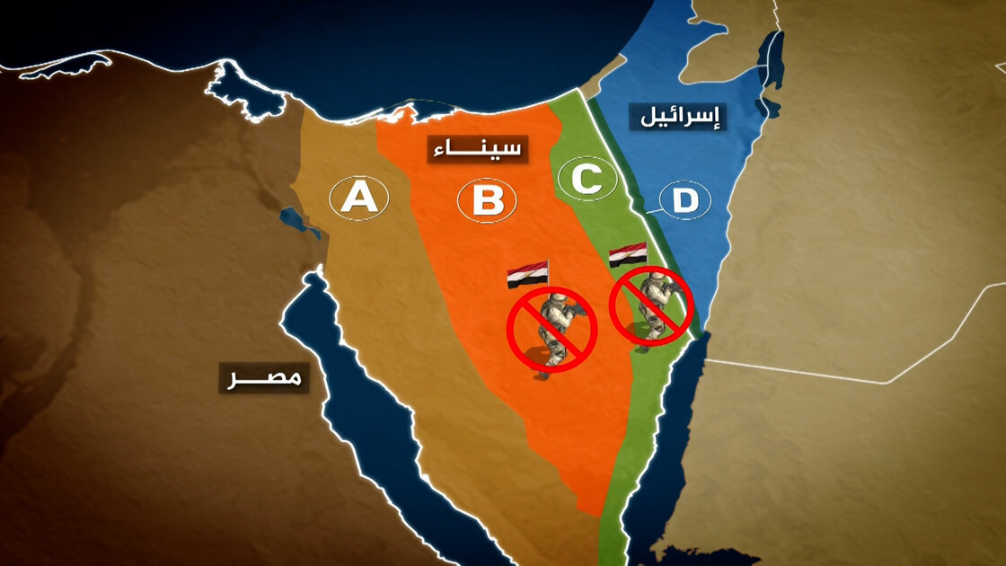
Gaza’s Gateway to the World and Resettlement Project
North Sinai Governorate has played a central role in developments related to the future of the Gaza Strip. Since Israel imposed a severe blockade on the Strip in 2007, North Sinai has been a refuge for Gazans to obtain essential necessities, with the Rafah crossing being their only access to the wider world.
When the Rafah crossing faced stringent restrictions or closure, Gazans were compelled to resort to North Sinai through other means.
In early 2008, following the closure of Rafah for over six months, thousands of Palestinians were forced to cross the Egyptian border after part of the border wall was destroyed, securing their needs for food, fuel, and other supplies.
As the blockade persisted, Gazans developed a system of digging tunnels beneath the borders to reach Egyptian Rafah for essential necessities.
Following the “Aqsa Flood” battle that began in October 2023, and the subsequent Israeli assault on the Strip, the Israeli Plan advocating the forced transfer of Gazans to North Sinai resurfaced after previous attempts to thwart it.
Israeli authorities pushed residents southward towards the Egyptian border. At the same time, the Egyptian authorities remained firm in their stance against the forced transfer of Gazans, refusing to let them migrate to Sinai.
Economy
Northern Sinai contributes about 1.8% to Egypt’s total gross domestic product, with an actual growth rate of approximately 3.2%.
The oil sector represents the largest sector of its economy, estimated at about 82%, whereas services account for 5%, manufacturing industries for 4%, and the remaining 9% is spread across other sectors, including agriculture, fisheries, and tourism. (Ministry of Planning and Economic Development indicators, December 2020).

Building of the oldest library in Sinai (Al Jazeera)
The poverty rate in this governorate exceeds the national average of 32.5% for 2017-2018, reaching 38.4% in the same period.
Unemployment among men stands at 32.3%, rising to 73.6% among women. (Ministry of Planning and Economic Development indicators, December 2018).
Prominent Landmarks
North Sinai Governorate hosts several notable landmarks, the most famous of which include:
- Pelusium Archaeological Site (Al-Farama): The most significant archaeological location in North Sinai, situated north of the village of Balouza. This site includes an archaeological city with a large Roman-era theater and fortress, several baths, and various archaeological mounds like Tell al-Kanais and Tell al-Shuhada.
- Archaeological Tells: The governorate has several archaeological tells dating back to different eras, including Pharaonic, Nabatean, Roman, and Islamic times, such as Tell al-Darawish, Tell Qasraweit, Tell al-Mahamid, and Tell al-Karama.
- Al-Arish Fortress: The sole remaining landmark in the city of Al-Arish, it was erected in 1560 by Sultan Suleiman the Magnificent on the ruins of an ancient Pharaonic fortress and included a well, a garden, and soldiers’ accommodations.
- Zaranik Protected Area: Located on the eastern end of Lake Bardawil, it spans about 250 square kilometers. Known as a transit hub for migratory birds, the area is also a breeding ground for some permanent avian species and a suitable nesting site for the endangered green sea turtles.